 |
|
GSICS Wiki>Development web>AtbdCentral>AtbdMainFooBar>AtbdStp1Prc1Lvl3ClsIReeGL (30 Oct 2009, AleksandarJelenak)


1.1.3. ATBD Step 1 Process 1 Level 3 Class IReeGL Title
Class IReeGL

 Hide Option v0.1
Option v0.1 Title
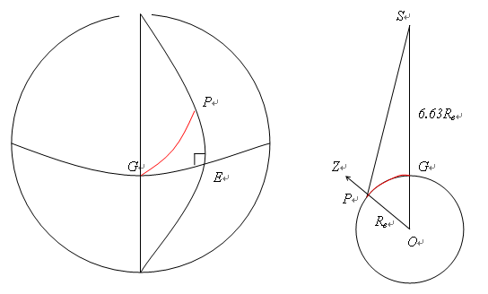
For inter-calibrations between geostationary and sun-synchronous satellites, the orbits provide collocations near the GEO Sub-Satellite Point (SSP) within fixed time windows every day and night. In this case, we adopt the simple approach outlined in general option v0.1. We define the GEO Field of Regard (FoR) as an area close to the GEO Sub-Satellite Point (SSP), which is viewed by the GEO sensor with a zenith angle less than a threshold. Wu [2009] defined a threshold angular distance from nadir of less than Figure 3: Computing arc angle to satellite nadir and zenith angle of satellite from Earth location
Option v0.2 Title
...Option v0.2 text...Option v0.3 Title
...Option v0.3 text...Option v0.4 Title
...Option v0.4 text...

| I | Attachment | Action | Size | Date | Who | Comment |
|---|---|---|---|---|---|---|
| |
computing_arc_angle.png | manage | 15 K | 30 Oct 2009 - 05:06 | HiromiOwada | Computing arc angle to satellite nadir and zenith angle of satellite from Earth location |
Edit | Attach | Print version | History: r5 < r4 < r3 < r2 | View wiki text | Edit wiki text | More topic actions
Topic revision: r5 - 30 Oct 2009, AleksandarJelenak
- Useful wiki links:
-
 Attach multiple files to current topic
-
 User wiki documentation
-
 Quick editing reference
-
 Good style tips
-
 Installed wiki extensions
-
 Member-only web
-
 Test Wiki
- Tag cloud:
(Clicking a tag finds all topics tagged with it.)
A Test Topic ATBD convention equations error assessment examples FAQ file naming GPPA GSICS Correction GSICS Monitoring Imager ISO 19115 JAMI Joint WG meeting LaTeX Logo Lunar Workshop meetings metadata microwave Moon MTSAT netCDF products solar channel SubGroup traceability users Web meeting workflow workshop workshops
Ideas, requests, problems regarding GSICS Wiki? Send feedback