 |
|
GSICS Wiki>Development web>MeetingsAndConferences>Sitsat (09 Jul 2024, ManikBali)


SITSat for GSICS
By Manik Bali and Lawrence E Flynn (NOAA) Table of Contents- GSICS Introduction
- SITSat missions as in-orbit GSICS References
- Simultaneous Nadir Overpass
- Simultaneous Nadir Overpass Prediction
- GSICS Inter-Calibration Products
- Tying GSICS Products to an Absolute (SITSat) Scale ( Tim Hewison, 2020)
- CLARREO, LIBRA and TRUTHS Measurement Spectrum ( Peng Zhang, 2020)
- CLARREO Pathfinder Mission
- Opportunities for Inter-Calibration, SITSat Orbits
- Tying GSICS Data Maturity to SITSat mission maturity
- Open Questions
- SITSat Meetings
GSICS Introduction
The Global Space-based Inter-Calibration System (GSICS) is an international collaborative effort initiated in 2005 by the World Meteorological Organization (WMO) and the Coordination Group for Meteorological Satellites (CGMS) to 1-monitor, 2-improve and 3-harmonize the quality of observations from operational weather and environmental satellites of the Global Observing System (GOS). GSICS aims at ensuring consistent accuracy among space-based observations worldwide for climate monitoring, weather forecasting, and environmental applications. A SITSat is a satellite-based sensor designed to provide verifiable evidence of all significant contributions to the uncertainty of its measurements. This is done openly and transparently, with traceability to the International System of Units (SI) at the specific location and time of the measurement. The community must consider the uncertainty level of ‘fiducial reference’ quality, meaning it is state-of-the-art within a defined spectral domain or application and can serve as a definitive reference for similar measurements from other sensors. The uncertainty of a SITSat should meet or approach the requirements for key climate science objectives, as outlined in the “SI-Traceable Space-based Climate Observing System: a CEOS and GCICS Workshop” (https://doi.org/10.47120/npl.9319). When used as a reference, a SITSat is expected to have a measurement uncertainty of less than 0.5 compared to its non-SITSat counterparts GSICS Wiki: http://gsics.atmos.umd.edu/wiki/Home GSICS Coordination Center: https://www.star.nesdis.noaa.gov/smcd/GCC/SITSat Missions
Three Sitraceable missions are planned to be launched. These are CLARREO(NASA), TRUTHS (ESA), and Libra (CSRB).
SITSat missions as in-orbit GSICS references
The SITSat missions are envisaged to be a game-changer for the GSICS community. For the first time, in-orbit Si Traceable measurements from Sit SAT missions can be used as a reference to compare measurements of concurrently flying missions with overlapping spectral bands during a Simultaneous Nadir Overpass event.*CLARREO, LIBRA and TRUTHS Measurement Spectrum*
 Figure Above Curtsey Pen Zhang 2021 Calibration and Recalibration: Theory, Practice, and Future Perspective
CLARREO (Climate Absolute Radiance and Refractivity Observatory)
Figure Above Curtsey Pen Zhang 2021 Calibration and Recalibration: Theory, Practice, and Future Perspective
CLARREO (Climate Absolute Radiance and Refractivity Observatory) - Objective: CLARREO is designed to provide highly accurate, SI-traceable measurements of the Earth’s radiation budget, which is crucial for understanding and predicting climate change.
- Scope: It aims to deliver benchmark climate records, which will help improve climate models and predictions.
- Instruments: CLARREO will carry instruments capable of observing reflected solar radiation and emitted thermal radiation with unprecedented accuracy.
- Objective**: CLARREO Pathfinder is a smaller, precursor mission to CLARREO, aimed at demonstrating the technologies and methodologies required for the full CLARREO mission.
- Scope**: This mission is intended to validate the instruments and techniques that will be used in the full CLARREO mission, thereby reducing risk and ensuring the success of the larger mission.
- Instruments**: CLARREO Pathfinder will carry a Reflected Solar instrument, which will be mounted on the International Space Station (ISS) to test the key technologies. Key Differences
- Mission Size and Scope**: CLARREO is a full-scale mission with a broader range of objectives and instruments, whereas CLARREO Pathfinder is a smaller, targeted mission focused on technology demonstration.
- Purpose**: CLARREO aims to provide long-term climate data records, while CLARREO Pathfinder is designed to ensure the feasibility and reliability of the technologies for the full mission.
- Deployment**: CLARREO Pathfinder operates from the ISS, whereas the full CLARREO mission would involve dedicated satellites.
Tying GSICS Products to an Absolute Scale
By Heiwson et al 2020 Many satellite missions attempt to calibrate their instruments against SI standards before launch. GSICS, working together with CEOS, aims to define best practices to characterize satellite instruments pre-launch using SI-traceable references to tie them to an absolute radiance scale. However, this traceability chain may be compromised during launch, due to uncontrolled changes to the instrument and its operating environment. For this reason, GSICS endorses the establishment of an observing system with calibration directly traceable to SI-standards on-orbit to act as an inter-calibration reference, which could be used to anchor inter-calibration products to an absolute scale—a long-term aim of GSICS. A satellite mission, such as CLARREO Pathfinder with HyperSpectral Imager for Climate Science (HySICS) 17], TRUTHS 18], in which an instrument is launched, whose SI-traceability is verifiable in orbit could be used as a reference to achieve this goal. These are generically referred to here as SI-Traceable Satellite instruments (SITSATs). In the simplest case, shown by the green arrow in Figure 1a, such a SITSAT can be used as a reference in direct inter-calibration of the monitored instrument by SNO or Ray-matching instead of the current reference instrument(s) for the IR case, or the PICTs in the VIS/NIR case. However, the coverage of the available collocated observations can be limited, depending on the design of the SITSAT—and the duration of such inter-calibration products is limited to their operating lifetime.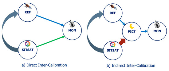 Figure 1. Different approaches to provide traceability of inter-calibration products for a Monitored instrument (MON) to an SI-Traceable Satellite instrument (SITSAT); Left (a): Direct Inter-Calibration: Using Ray-matching/SNO-like approach to transfer the calibration of Reference Instrument (REF) or SITSAT to MON (blue/green arrows); Right (b): Indirect Inter-Calibration: Using a Pseudo Invariant Calibration Target (PICT) to transfer calibration of REF or SITSAT to MON (blue/red arrows). Alternatively, the SITSAT calibration can be transferred to MON by first recalibrating the REF—either directly or indirectly, as shown by the curled grey arrows in (a) and (b).
SITSat Orbits
Each of the three SITSat missions has a distinct orbit CLARREO Pathfinder would be onboard the International Space Station (ISS) (red) at 400 km altitude and 51.6° orbit inclination, crossing under the Suomi-NPP or NOAA-20 orbit track (green) at ~830 km altitude, in a 13:30 Local Time sun-synchronous 98.7° orbit. Lukashin et al., 2013 have detailed the SNO opportunities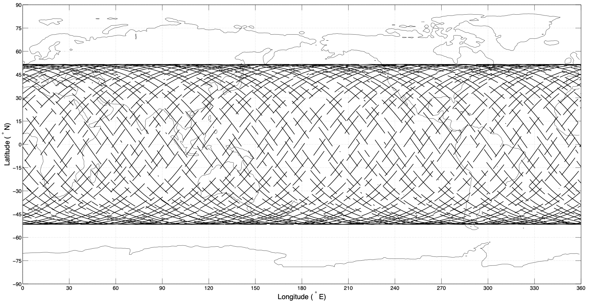 Figure Above: Predicted inter-calibration events between CLARREO Pathfinder on ISS and CERES/VIIRS on NOAA-20 during 1 year of operations. There are about 1,300 viable inter-calibration events. (Courtesy NASA)
Tying GSICS Data Maturity to SITSat data maturity
GSICS Procedure for Product Acceptance (GPPA) is the ...- GSICS product developers pathway to obtain a "Stamp of Approval" for a potential product
- GSICS data users window to GSICS product quality and "fitness for purpose"
- GSICS governing body reference for judging GSICS product fitness
- Product Submission Phase:A GSICS Product Acceptance Form for a potential product has been satisfactorily completed and submitted to the GSICS Coordination Center
- Demonstration Phase:The Product is determined to be within GSICS scope, its fundamental founding concepts are understood, and it meets GSICS data format/content guidelines. In this phase, the Product is released solely for the purpose of evaluation within GSICS and by potential product users
- Pre-Operational Phase:The Product has been determined to be a valuable part of the GSICS product portfolio, and has developed and understood methodology, software, supporting models and measurements, uncertainty, quality indicator, and traceability to a community or SI standard
- Operational Phase:In addition to its Pre-Operational Phase attributes, the Product has developed and understood generation, distribution, version control and archive strategies. It also has an available User's Guide. At this point, Product is fully accepted and maintained within GSICS
 How is GPPA connected to SITSat missions
The GPPA is a special case of the QA4EO architecture. The maturity of reference data that the SitSAT mission would provide for GSICS style inter-calibration is a key parameter that is used to assign maturity to GSICS inter-calibration products.
How is GPPA connected to SITSat missions
The GPPA is a special case of the QA4EO architecture. The maturity of reference data that the SitSAT mission would provide for GSICS style inter-calibration is a key parameter that is used to assign maturity to GSICS inter-calibration products.
Open Questions
1) Would the parent QA4EO be modified to assign maturity to the SITSat mission observations?
2) What would be the metadata conventions to be used in the file formats of the SITSat missions
3) What is the expected timeliness of SITSat be available to users for inter-calibration ( real time and what platforms)
Clarreo Path Finder Data Dissemination and Availability
CLARREO Pathfinder data will be publicly available from the Atmospheric Science Data Center (ASDC), which has been assigned as the mission’s Distributed Active Archive Center. More details on https://clarreo-pathfinder.larc.nasa.gov/science-overview/#cpf-data-products
GSICS SITSat meetings
SI-Traceable Space-based Climate Observing System Workshop (SITSCOS) - Event Dates: 9-11 September 2019 - National Physical Laboratory in London, UK https://calvalportal.ceos.org/sitscos-ws This meeting was followed by a recent TRUTHS workshop. Earth's Spectrally Resolved Reflected Radiation - TRUTHS for Climate Workshop Event Dates: 27-28 June, 2024 Harwell Science and Innovation Campus, UK. https://nikal.eventsair.com/truths-workshop/References
Cao, C., M. Weinreb, and H. Xu, 2004: Predicting Simultaneous Nadir Overpasses among Polar-Orbiting Meteorological Satellites for the Intersatellite Calibration of Radiometers. J. Atmos. Oceanic Technol., 21, 537–542, https://doi.org/10.1175/1520-0426(2004)021<0537:PSNOAP>2.0.CO;2. Hewison, T.J.; Doelling, D.R.; Lukashin, C.; Tobin, D.; O. John, V.; Joro, S.; Bojkov, B. Extending the Global Space-Based Inter-Calibration System (GSICS) to Tie Satellite Radiances to an Absolute Scale. Remote Sens. 2020, 12, 1782. https://doi.org/10.3390/rs12111782 Lukashin, C., B. Wielicki, D. Young, K. J. Thome, Z. Jin, and W. Sun (2013), Uncertainty Estimates for Imager Reference Inter-calibration with CLARREO Reflected Solar Spectrometer, IEEE TRANSACTIONS ON GEOSCIENCE AND REMOTE SENSING, 51, doi:10.1109/TGRS.2012.2233480. Zhang, P.; Lu, N.; Li, C.; Ding, L.; Zheng, X.; Zhang, X.; Hu, X.; Ye, X.; Ma, L.; Xu, N.; et al. Development of the Chinese Space-Based Radiometric Benchmark Mission LIBRA. Remote Sens. 2020, 12 , 2179. https://doi.org/10.3390/rs12142179 Libra Specifications: https://www.eoportal.org/satellite-missions/libra#overview https://clarreo-pathfinder.larc.nasa.gov/Edit | Attach | Print version | History: r6 < r5 < r4 < r3 | View wiki text | Edit wiki text | More topic actions
Topic revision: r6 - 09 Jul 2024, ManikBali
- Useful wiki links:
-
 Attach multiple files to current topic
-
 User wiki documentation
-
 Quick editing reference
-
 Good style tips
-
 Installed wiki extensions
-
 Member-only web
-
 Test Wiki
- Tag cloud:
(Clicking a tag finds all topics tagged with it.)
A Test Topic ATBD convention equations error assessment examples FAQ file naming GPPA GSICS Correction GSICS Monitoring Imager ISO 19115 JAMI Joint WG meeting LaTeX Logo Lunar Workshop meetings metadata microwave Moon MTSAT netCDF products solar channel SubGroup traceability users Web meeting workflow workshop workshops
Ideas, requests, problems regarding GSICS Wiki? Send feedback